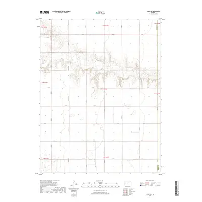
2018 Map of Pence SW
USGS Topo · Published 2018About this map
Marienthal Rd serves as the primary north-south artery through this section of the High Plains, dividing the expansive agricultural tracts of Wichita County. The landscape is characterized by a high plateau surface deeply incised by a meandering drainage system that cuts east-west across the central portion of the sheet. This topographic break provides a sharp contrast to the surrounding section-line grid of rural routes such as Co Rd G and Co Rd N. Along the eastern margin, the Wichita Co and Scott Co line follows Co Rd 25, marking a rigid political boundary across the undulating terrain. The drainage patterns suggest intermittent water flow through complex draws, typical of the western Kansas steppe, where the natural contours of the land frequently dictate land use despite the rectilinear survey system.
Find a feature on this map
25 named features on this map. Tap any name to fly to it.
Don’t see what you’re looking for? This feature index may not catch every label — zoom into the map to look around manually.
Map Details
Editions of this 2018 Pence SW Map
This is the sole edition of this map. No revisions or reprints were ever made.
Other maps of this area

1939 · Pence
USGS Topo · 1:62,500

1941 · Modoc
USGS Topo · 1:62,500

1941 · Pence
USGS Topo · 1:62,500

1951 · Modoc
USGS Topo · 1:62,500

1955 · Scott City
USGS Topo · 1:250,000

1958 · Scott City
USGS Topo · 1:250,000

1968 · Russell Springs 3 SE
USGS Topo · 1:24,000

1968 · Russell Springs 3 NE
USGS Topo · 1:24,000

1970 · Leoti
USGS Topo · 1:24,000
1976 · Pence
USGS Topo · 1:24,000