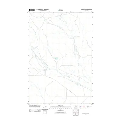
2011 Map of Pender Coulee
USGS Topo · Published 2011About this map
Willow Creek and Jones Creek define the drainage patterns of this central Montana landscape, where the open terrain is marked by the distinct topographic depression of Pender Coulee. This 2011 survey by the U.S. Geological Survey shows a rural region structured primarily by livestock management and watershed geography. Local infrastructure is concentrated around water sources and essential transit routes, with Miller Lake and the Joe Toe Dam serving as significant landmarks in an area dominated by grazing land. Roads such as Snowy Mountain Rd and Grazing District Rd provide the primary access through the territory, crossing seasonal waterways like Minerva Creek and Whoop-Up Creek. The map documents a sparsely populated but active ranching environment at the start of the 21st century.
Find a feature on this map
10 named features on this map. Tap any name to fly to it.
Don’t see what you’re looking for? This feature index may not catch every label — zoom into the map to look around manually.
Map Details
Editions of this 2011 Pender Coulee Map
This is the sole edition of this map. No revisions or reprints were ever made.
Other maps of this area

1954 · Roundup
USGS Topo · 1:250,000

1958 · Roundup
USGS Topo · 1:250,000

1986 · Tyler
USGS Topo · 1:24,000

1986 · Devils Hole Lake
USGS Topo · 1:24,000

1986 · Pender Coulee
USGS Topo · 1:24,000

1986 · Pike Creek Hills West
USGS Topo · 1:24,000

1986 · Lake Mason NW
USGS Topo · 1:24,000

1986 · Emory School
USGS Topo · 1:24,000
1986 · Timber Buttes North
USGS Topo · 1:24,000
1986 · Bald Butte
USGS Topo · 1:24,000