
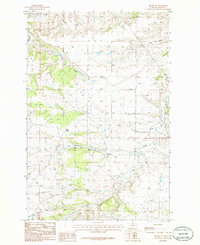
1986 Map of Pike Creek Hills West
USGS Topo · Published 1986About this map
Pike Creek Hills dominate this section of Central Montana, defining a landscape of high ridges and deep drainages. The map records a sparsely settled territory along the border of Fergus Co and Petroleum Co, where topographic elevation ranges from the high slopes of the hills down to the winding course of Flatwillow Creek in the south.
Find a feature on this map
9 named features on this map. Tap any name to fly to it.
Don’t see what you’re looking for? This feature index may not catch every label — zoom into the map to look around manually.
Map Details
Editions of this 1986 Pike Creek Hills West Map
This is the sole edition of this map. No revisions or reprints were ever made.
Other maps of this area

1954 · Roundup
USGS Topo · 1:250,000

1958 · Roundup
USGS Topo · 1:250,000

1986 · Tyler
USGS Topo · 1:24,000

1986 · Snoose Creek
USGS Topo · 1:24,000

1986 · Pender Coulee
USGS Topo · 1:24,000

1986 · Lake Mason NE
USGS Topo · 1:24,000

1986 · Lake Mason NW
USGS Topo · 1:24,000

1986 · Pike Creek Hills East
USGS Topo · 1:24,000

1986 · Milk Springs
USGS Topo · 1:24,000
1986 · Becket NE
USGS Topo · 1:24,000