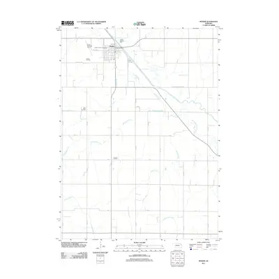
2011 Map of Pender
USGS Topo · Published 2011About this map
Pender sits as the primary hub of this landscape, situated along the modified course of the Logan Creek Dredge. The map reveals a transition between the developed grid of the town, featuring the Pender Post Office and Pender Municipal Airport, and the surrounding agricultural tracts. For those researching local family history, several prominent burial grounds are documented, including Rosehill Cemetery on the western edge of town, and more remote sites like Saint Marks Cemetery and Covenant Cemetery.
Find a feature on this map
34 named features on this map. Tap any name to fly to it.
Don’t see what you’re looking for? This feature index may not catch every label — zoom into the map to look around manually.
Map Details
Editions of this 2011 Pender Map
This is the sole edition of this map. No revisions or reprints were ever made.
Other maps of this area

1955 · Sioux City
USGS Topo · 1:250,000

1955 · Fremont
USGS Topo · 1:250,000

1957 · Fremont
USGS Topo · 1:250,000

1958 · Sioux City
USGS Topo · 1:250,000

1958 · Fremont
USGS Topo · 1:250,000

1959 · Sioux City
USGS Topo · 1:250,000

1966 · West Point NW
USGS Topo · 1:24,000
1966 · Beemer
USGS Topo · 1:24,000

1966 · West Point NE
USGS Topo · 1:24,000
1966 · Bancroft
USGS Topo · 1:24,000