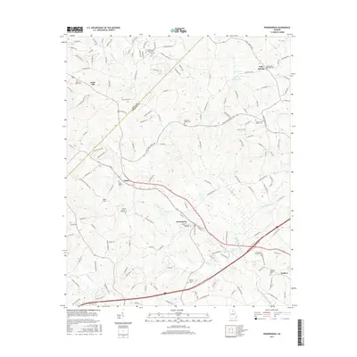
2017 Map of Pendergrass
USGS Topo · Published 2017About this map
Pendergrass and Talmo anchor this detailed study of Jackson County’s Piedmont terrain, where the headwaters of the Middle Oconee River meet a dense network of local creeks. The landscape is heavily marked by small community landmarks and family heritage sites, particularly the numerous Baptist congregations and their associated burial grounds. Tracing along the western edge, the Hall Co Jackson Co line bisects the area near Sugar Hill, while the central corridor follows the path of the railroad through Pendergrass. Notable water bodies such as Allen Cr, Pond Fork, and several numbered reservoirs like Reservoir Six and Reservoir 12 define the local drainage patterns. Significant for genealogists, the map identifies numerous small cemeteries including Jarrett Cem, White Cem, and the Pendergrass City Cem, alongside rural junctions such as Holders and Holly Springs.
Find a feature on this map
162 named features on this map. Tap any name to fly to it.
Don’t see what you’re looking for? This feature index may not catch every label — zoom into the map to look around manually.
Map Details
Editions of this 2017 Pendergrass Map
This is the sole edition of this map. No revisions or reprints were ever made.
Other maps of this area

1891 · Gainesville
USGS Topo · 1:125,000

1954 · Greenville
USGS Topo · 1:250,000

1958 · Greenville
USGS Topo · 1:250,000

1964 · Maysville
USGS Topo · 1:24,000

1964 · Chestnut Mountain
USGS Topo · 1:24,000
1964 · Winder North
USGS Topo · 1:24,000
1964 · Auburn
USGS Topo · 1:24,000

1964 · Gainesville
USGS Topo · 1:24,000

1964 · Pendergrass
USGS Topo · 1:24,000
1964 · Jefferson
USGS Topo · 1:24,000