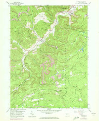
1959 Map of Penfield
USGS Topo · Published 1972About this map
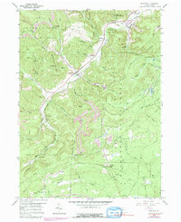
Penfield and the neighboring settlements of Winterburn and Hollywood define this section of the Allegheny Plateau during a period of industrial and conservation activity. The landscape is heavily marked by the extraction economy, with a Strip Mine and Gravel Pit visible alongside the Penn Central rail line that follows the course of Bennett Branch. Much of the territory is dedicated to public land management, including the Moshannon State Forest, State Game Lands No 93, and Parker Dam State Park. For genealogists, the presence of Mt Pleasant Cem and Laurel Run Cem provides vital points of interest for family research. The map also highlights local infrastructure like the Pumping Station and the State Tree Nursery, reflecting the state's efforts in reforestation and water management across the numerous runs and hollows feeding into Anderson Creek and Moshannon Creek.
Find a feature on this map
60 named features on this map. Tap any name to fly to it.
Don’t see what you’re looking for? This feature index may not catch every label — zoom into the map to look around manually.
Map Details
Editions of this 1959 Penfield Map
5 editions found
Other maps of this area

1929 · Clearfield
USGS Topo · 1:48,000

1929 · Penfield
USGS Topo · 1:62,500

1932 · Clearfield
USGS Topo · 1:62,500

1932 · Penfield
USGS Topo · 1:62,500

1941 · Benezette
USGS Topo · 1:62,500

1941 · Ridgway
USGS Topo · 1:62,500

1943 · Benezette
USGS Topo · 1:62,500

1944 · Ridgway
USGS Topo · 1:62,500

1957 · Warren
USGS Topo · 1:250,000

1958 · Warren
USGS Topo · 1:250,000
Featured Places
- Pine Township, PA
- Gobbler Knob, Huston Township
- Fox Township, PA
- Penfield, Huston Township
- Anderson Creek, Pine Township