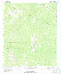
1972 Map of Penfield
USGS Topo · Published 1991About this map
Penfield and the surrounding woodlands of the Oconee National Forest define this 1970s landscape along the border of Oglethorpe and Greene Counties. The map records a rural network of small agricultural settlements and historic congregations, including the Old Mercer Chapel and Bethabara Ch. These local landmarks, alongside Harmonia Ch and Shiloh Ch, reflect the deep community roots of the Georgia Piedmont. Waterways like Fishing Creek and Town Creek wind through the hills, while the Georgia railroad line passes through Woodville and Maxeys in the northeast. For genealogists and local historians, the inclusion of family-named sites such as Janes Cem and Boswell Chapel Cem provides specific data points for tracing family lineages in the region during this era.
Find a feature on this map
23 named features on this map. Tap any name to fly to it.
Don’t see what you’re looking for? This feature index may not catch every label — zoom into the map to look around manually.
Map Details
Editions of this 1972 Penfield Map
2 editions found
Other maps of this area

1953 · Athens
USGS Topo · 1:250,000

1958 · Athens
USGS Topo · 1:250,000

1959 · Athens
USGS Topo · 1:250,000

1963 · Athens
USGS Topo · 1:250,000

1964 · Barnett Shoals
USGS Topo · 1:24,000

1965 · Woodville
USGS Topo · 1:24,000

1965 · Union Point
USGS Topo · 1:24,000

1971 · Maxeys
USGS Topo · 1:24,000
1971 · Lexington
USGS Topo · 1:24,000

1972 · Penfield
USGS Topo · 1:24,000