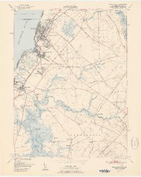
1951 Map of Penns Grove
USGS Topo · Published 1951About this map
Penns Grove and the industrialized shoreline of the Delaware River define this mid-century survey of Salem County. The landscape is a mix of dense riverfront settlements like Carneys Point and Deepwater contrasted with the marshy lowlands of Pine Island Meadow and Kates Creek Meadow. Transportation is a primary theme, from the Wilmington Ferry Slip connecting to Delaware to the Reading Seashore Lines rail network featuring Friendship Sta and Perkintown Sta. Moving inland, the map reveals a more agrarian character in Upper Penns Neck and Haines Neck, where small family-named crossroads like Raines Corner and Slapes Corner served local farmers. Genealogists can locate rural institutions such as Haines Neck Ch and Concord Sch before post-war suburban expansion significantly altered the South Jersey interior.
Find a feature on this map
69 named features on this map. Tap any name to fly to it.
Don’t see what you’re looking for? This feature index may not catch every label — zoom into the map to look around manually.
Map Details
Editions of this 1951 Penns Grove Map
2 editions found
Other maps of this area

1890 · Salem
USGS Topo · 1:62,500

1894 · Chester
USGS Topo · 1:62,500

1896 · Chester
USGS Topo · 1:62,500

1898 · Salem
USGS Topo · 1:62,500

1898 · Chester
USGS Topo · 1:62,500

1901 · Camden
USGS Topo · 1:125,000

1901 · West Chester
USGS Topo · 1:62,500

1904 · West Chester
USGS Topo · 1:62,500

1904 · Wilmington
USGS Topo · 1:62,500

1906 · Wilmington
USGS Topo · 1:62,500