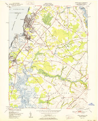
1951 Map of Penns Grove
USGS Topo · Published 1951About this map
Penns Grove and its surrounding riverfront neighborhoods dominate the eastern bank of the Delaware River, where the industrial and transit landscape of the mid-20th century is clearly defined. The area’s growth is tied to the Reading Seashore Lines and a network of ferries, including the Wilmington Ferry Slip, which linked New Jersey commuters and commerce to the city across the water. Moving inland, the map transitions into the rural reaches of Haines Neck and Mannington, characterized by a patchwork of small creeks like Two Penny Run and Game Creek. This transition from the densely settled streets of Carneys Point to the quiet agrarian sites of Mt Zion Ch and Concord Sch illustrates the sharp divide between the river's industrial activity and the interior's farming roots.
Find a feature on this map
72 named features on this map. Tap any name to fly to it.
Don’t see what you’re looking for? This feature index may not catch every label — zoom into the map to look around manually.
Map Details
Editions of this 1951 Penns Grove Map
2 editions found
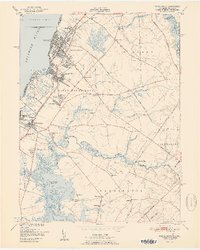
Other maps of this area

1890 · Salem
USGS Topo · 1:62,500

1894 · Chester
USGS Topo · 1:62,500

1896 · Chester
USGS Topo · 1:62,500

1898 · Salem
USGS Topo · 1:62,500

1898 · Chester
USGS Topo · 1:62,500

1901 · Camden
USGS Topo · 1:125,000

1901 · West Chester
USGS Topo · 1:62,500

1904 · West Chester
USGS Topo · 1:62,500

1904 · Wilmington
USGS Topo · 1:62,500

1906 · Wilmington
USGS Topo · 1:62,500