1951 Map of Penola
USGS Topo · Published 1951About this map
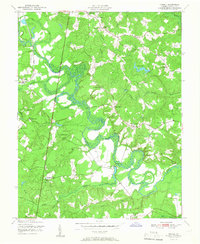
The Mattaponi River meanders through the central Virginia landscape of Caroline County, its tight oxbows defining the local geography. Following the 1947 aerial surveys and 1949 field checks, this map illustrates a rural society organized around family-named intersections and crossroad communities such as Penola, Kidds Fork, and Doggetts Fork. The western edge is defined by the Richmond Fredericksburg and Potomac rail corridor, which provided a vital connection through the region.
Find a feature on this map
30 named features on this map. Tap any name to fly to it.
Don’t see what you’re looking for? This feature index may not catch every label — zoom into the map to look around manually.
Map Details
Editions of this 1951 Penola Map
This is the sole edition of this map. No revisions or reprints were ever made.
Other maps of this area

1889 · Fredericksburg
USGS Topo · 1:125,000

1892 · Fredericksburg
USGS Topo · 1:125,000

1894 · Fredericksburg
USGS Topo · 1:125,000

1918 · Doswell
USGS Topo · 1:62,500

1918 · Aylett
USGS Topo · 1:62,500

1933 · Aylett
USGS Topo · 1:62,500

1942 · Bowling Green
USGS Topo · 1:31,680

1942 · Upper Zion
USGS Topo · 1:31,680

1942 · Woodford
USGS Topo · 1:31,680

1943 · Richmond
USGS Topo · 1:250,000