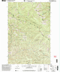
1999 Map of Penrose Peak
USGS Topo · Published 2003About this map
The Coeur d'Alene Mountains dominate this landscape within the Lolo National Forest, where the high ridgelines of the Coeur d'Alene Divide separate the Thompson Falls and Superior Ranger Districts. Notable summits like Penrose Peak and Cherry Peak overlook a dense network of drainages, including Cherry Creek and Rock Creek. This 1999 revision captures a wilderness region largely defined by its natural topography and resource management, with evidence of human activity limited to remote industrial features such as a Gravel Pit and a lone Adit. Small water bodies like Acorn Lake sit high in the drainage basins, while lower elevations are marked by distinct landforms like Greenwood Hill. The boundary between Sanders and Mineral Counties follows the rugged spine of the mountains, illustrating how the physical terrain dictated political and administrative borders in western Montana.
Find a feature on this map
25 named features on this map. Tap any name to fly to it.
Don’t see what you’re looking for? This feature index may not catch every label — zoom into the map to look around manually.
Map Details
Editions of this 1999 Penrose Peak Map
This is the sole edition of this map. No revisions or reprints were ever made.
Other maps of this area

1918 · St Regis
USGS Topo · 1:125,000

1919 · St. Regis
USGS Topo · 1:125,000

1937 · Thompson Falls
USGS Topo · 1:125,000

1937 · Thompson Falls
USGS Topo · 1:62,500

1956 · St Regis
USGS Topo · 1:62,500

1956 · Wallace
USGS Topo · 1:250,000

1957 · Thompson Falls
USGS Topo · 1:62,500

1957 · Haugan
USGS Topo · 1:62,500

1960 · Wallace
USGS Topo · 1:250,000

1964 · Eddy Mountain
USGS Topo · 1:24,000