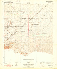
1950 Map of Pentland
USGS Topo · Published 1950About this map
Maricopa Flat serves as the industrial centerpiece of this mid-century Kern County landscape, dominated by a concentrated network of petroleum extraction and processing infrastructure. The map reveals the intense development of the regional oil industry, featuring facilities like the Richfield Refining Plant No 1, Lakeview Refining Co, and the O C Fields Refining Plant No 2. This industrial activity is supported by specialized worker settlements such as the General Petroleum Corp Essex Camp and the Associated Oil Co Western Mineral Camp. Beyond the refineries, the terrain transitions into the steep relief of Cienaga Canyon and the drainage of Bitter Water Creek. To the north, the presence of Gardner Field and the junction of the Mt Diablo Base and Meridian with the San Bernardino Base and Meridian highlights the area's importance as a surveying and logistical hub.
Find a feature on this map
16 named features on this map. Tap any name to fly to it.
Don’t see what you’re looking for? This feature index may not catch every label — zoom into the map to look around manually.
Map Details
Editions of this 1950 Pentland Map
This is the sole edition of this map. No revisions or reprints were ever made.
Other maps of this area

1903 · Mt. Pinos
USGS Topo · 1:125,000

1910 · Buena Vista Lake
USGS Topo · 1:125,000

1912 · Buena Vista Lake
USGS Topo · 1:125,000

1929 · Mouth of Kern
USGS Topo · 1:31,680

1930 · Millux
USGS Topo · 1:31,680

1931 · Pentland Junction
USGS Topo · 1:31,680

1931 · Hayes Ranch
USGS Topo · 1:31,680

1932 · Mouth of Kern
USGS Topo · 1:31,680

1933 · Hayes Ranch
USGS Topo · 1:31,680
1933 · Millux
USGS Topo · 1:31,680