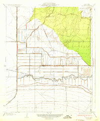
1933 Map of Millux
USGS Topo · Published 1933About this map
Buena Vista Lake Bed dominates the central landscape of this Kern County survey, revealing a complex hydraulic environment defined by reclaiming the San Joaquin Valley floor. A dense network of man-made waterways, including the Alejandro Canal, Stine Canal, and Sunset Ry Canal, crisscrosses the terrain, illustrating the intensive engineering required to manage water for agriculture and ranching. The presence of the East Levee and various ditches like the New Rim Ditch further highlights the transformation of the natural drainage system, including the winding Connecting Slough.
Find a feature on this map
18 named features on this map. Tap any name to fly to it.
Don’t see what you’re looking for? This feature index may not catch every label — zoom into the map to look around manually.
Map Details
Editions of this 1933 Millux Map
3 editions found
Other maps of this area

1910 · Buena Vista Lake
USGS Topo · 1:125,000

1912 · Buena Vista Lake
USGS Topo · 1:125,000

1929 · Stevens
USGS Topo · 1:31,680

1929 · Coles Levee
USGS Topo · 1:31,680

1929 · Mouth of Kern
USGS Topo · 1:31,680

1930 · Millux
USGS Topo · 1:31,680

1930 · Conner
USGS Topo · 1:31,680

1931 · Pentland Junction
USGS Topo · 1:31,680

1931 · Hayes Ranch
USGS Topo · 1:31,680

1932 · Mouth of Kern
USGS Topo · 1:31,680