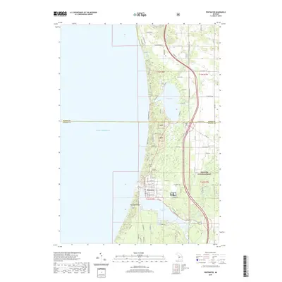
2019 Map of Pentwater
USGS Topo · Published 2019About this map
Pentwater serves as the focal point of this coastal survey, where the village and the smaller settlement of French Town overlook the channel connecting Pentwater Lake to the expanse of Lake Michigan. The landscape is defined by its complex hydrography, including the Little Bayou and Big Bayou wetlands and the winding course of the Pentwater River. Further north, Bass Lake sits behind the dunes, fed by Kibby Creek and Quinn Creek. Much of the eastern interior falls within the Manistee National Forest, where a network of section-line roads like Washington Road and Oceana Road cross the county line between Mason and Oceana Counties. Genealogists may find the Pentwater Township Cemetery particularly relevant, situated just north of the village center. This contemporary record captures the shoreline and forest boundaries as they stood in the late 2010s.
Find a feature on this map
36 named features on this map. Tap any name to fly to it.
Don’t see what you’re looking for? This feature index may not catch every label — zoom into the map to look around manually.
Map Details
Editions of this 2019 Pentwater Map
This is the sole edition of this map. No revisions or reprints were ever made.
Other maps of this area

1931 · Hart NW
USGS Topo · 1:31,680

1931 · Hart NE
USGS Topo · 1:31,680

1932 · Ludington NE
USGS Topo · 1:31,680

1932 · Ludington SW
USGS Topo · 1:31,680

1932 · Ludington SE
USGS Topo · 1:31,680

1932 · Ludington
USGS Topo · 1:31,680

1954 · Milwaukee
USGS Topo · 1:250,000

1958 · Milwaukee
USGS Topo · 1:250,000

1959 · Ludington
USGS Topo · 1:62,500

1959 · Hart
USGS Topo · 1:62,500