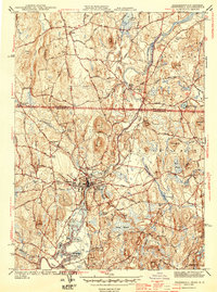
1944 Map of Pepperell
USGS Topo · Published 1944About this map
The Nashua River and its tributary, the Nissitissit River, dictate the settlement patterns of this 1940s borderland between New Hampshire and Massachusetts. At the center of the regional rail economy sits Hollis Depot, a vital junction on the Boston and Maine Railroad that once linked these rural communities to broader industrial markets. The map reveals a landscape transitioning from agrarian roots to mid-century development, marked by numerous family-named landmarks and historical cemeteries such as St Louis De Gonzague Cem and the Blood Cem. Significant wetland features like Reedy Meadow and Hawk Swamp dominate the lower eastern terrain, while named elevations like Proctor Hill and Blanchard Hill frame the river valleys. From the established town centers of Pepperell and East Pepperell to smaller crossroads like Hovey Corner, this survey documents the infrastructure of the Nashua River valley during the Second World War era.
Find a feature on this map
51 named features on this map. Tap any name to fly to it.
Don’t see what you’re looking for? This feature index may not catch every label — zoom into the map to look around manually.
Map Details
Editions of this 1944 Pepperell Map
2 editions found
Other maps of this area

1886 · Lowell
USGS Topo · 1:62,500

1893 · Lowell
USGS Topo · 1:62,500

1893 · Groton
USGS Topo · 1:62,500

1905 · Manchester
USGS Topo · 1:62,500

1906 · Milford
USGS Topo · 1:62,500

1918 · Lowell
USGS Topo · 1:62,500

1921 · Lowell
USGS Topo · 1:62,500

1931 · Lowell
USGS Topo · 1:48,000

1931 · Groton
USGS Topo · 1:48,000

1935 · Ayer
USGS Topo · 1:24,000