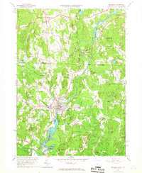
1965 Map of Pepperell
USGS Topo · Published 1967About this map
The Nashua River and Nissitissit River converge in this mid-1960s study, defining a landscape of industrial river towns and rural New Hampshire-Massachusetts borderland. The manufacturing and transit heritage of Pepperell and East Pepperell is evident through the path of the Boston and Maine Railroad and the concentration of local landmarks such as the Fitzpatrick Sch and the Covered Bridge spanning the river. North across the state line, Hollis maintains a more agrarian character, punctuated by sites like Hollis Depot and South Cem.
Find a feature on this map
72 named features on this map. Tap any name to fly to it.
Don’t see what you’re looking for? This feature index may not catch every label — zoom into the map to look around manually.
Map Details
Editions of this 1965 Pepperell Map
3 editions found
Other maps of this area

1886 · Lowell
USGS Topo · 1:62,500

1893 · Lowell
USGS Topo · 1:62,500

1893 · Groton
USGS Topo · 1:62,500

1905 · Manchester
USGS Topo · 1:62,500

1906 · Milford
USGS Topo · 1:62,500

1918 · Lowell
USGS Topo · 1:62,500

1921 · Lowell
USGS Topo · 1:62,500

1931 · Lowell
USGS Topo · 1:48,000

1931 · Groton
USGS Topo · 1:48,000

1935 · Ayer
USGS Topo · 1:24,000