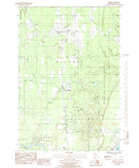
1985 Map of Perkins
USGS Topo · Published 1985About this map
Perkins and Brampton serve as central points in this mid-1980s survey of Delta County, situated along the Chicago and North Western rail corridor. The map documents a landscape defined by its waterways, including the winding course of the Tacoosh River and the Days River, which flow south toward Little Bay de Noc. Local history and genealogy are well-represented by the inclusion of St Josephs Ch, Bethany Ch, and the Perkins Cem near the junction of several rural routes. To the east, the boundary of the Hiawatha National Forest marks a transition into more heavily timbered land, while the southern edge follows the Escanaba River near the settlement of Chaison. The mapping of several pipelines and a Micro Wave Tower illustrates the modernization of infrastructure through this rural Upper Peninsula landscape.
Find a feature on this map
38 named features on this map. Tap any name to fly to it.
Don’t see what you’re looking for? This feature index may not catch every label — zoom into the map to look around manually.
Map Details
Editions of this 1985 Perkins Map
This is the sole edition of this map. No revisions or reprints were ever made.
Other maps of this area

1932 · Gladstone NE
USGS Topo · 1:31,680

1932 · Rock SW
USGS Topo · 1:31,680

1932 · Trenary SW
USGS Topo · 1:31,680

1932 · Gladstone SE
USGS Topo · 1:31,680

1932 · Rapid River NW
USGS Topo · 1:31,680

1932 · Rock SE
USGS Topo · 1:31,680

1932 · Rapid River SW
USGS Topo · 1:31,680

1932 · Gladstone SW
USGS Topo · 1:31,680

1932 · Gladstone NW
USGS Topo · 1:31,680

1950 · Gladstone NW
USGS Topo · 1:31,680