
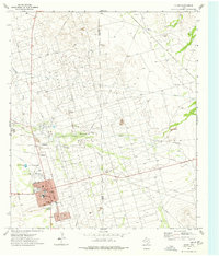
1964 Map of Perkins Lake
USGS Topo · Published 1967About this map
Industrial development across the West Texas desert defines this landscape at the intersection of Crane and Upton counties. The central feature is the extensive Oil Field that punctuates the arid terrain between Concho Bluff and Landreth Draw. A complex network of pipelines and countless Oil Wells shows the intensive resource extraction of the mid-1960s, while numerous family-named landmarks such as the Pee Wee Windmill, Shilie Windmill, and Blackeye Windmill reflect the area's ranching heritage. The rare presence of surface water at Perkins Lake in the north and the shifting sands of the Dune to the southwest highlight the environmental extremes of the Permian Basin. This survey documents the transition from traditional ranching operations, like the Glass and Everitt Ranch, to a modern economy dominated by petroleum production.
Find a feature on this map
20 named features on this map. Tap any name to fly to it.
Don’t see what you’re looking for? This feature index may not catch every label — zoom into the map to look around manually.
Map Details
Editions of this 1964 Perkins Lake Map
This is the sole edition of this map. No revisions or reprints were ever made.
Other maps of this area

1928 · Crane
USGS Topo · 1:125,000

1954 · Pecos
USGS Topo · 1:250,000

1957 · Pecos
USGS Topo · 1:250,000

1964 · Doodle Bug Well
USGS Topo · 1:24,000

1964 · Clark Brothers Ranch
USGS Topo · 1:24,000

1965 · South Cowden Ranch
USGS Topo · 1:24,000

1968 · Benge Corner NW
USGS Topo · 1:24,000

1968 · Benge Corner SW
USGS Topo · 1:24,000

1971 · McElroy Ranch
USGS Topo · 1:24,000
1974 · Crane
USGS Topo · 1:24,000