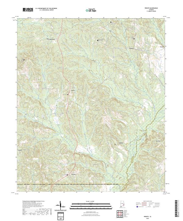
2024 Map of Perote
USGS Topo · Published 2024About this map
Perote and Blues Old Stand anchor this portion of Bullock County, where the upper reaches of the Pea River and Big Sandy Creek carve through the landscape. The settlement pattern here is deeply rooted in local genealogy, evidenced by a high density of family-named burial grounds like Old Sellers Cem, Cope Hoffman Cem, and Rogers Cem. This rural network is defined by its small crossroads communities, including Smuteye, Jamback, and Tanyard, which are connected by a web of county roads such as Bullock Co 14 and Smuteye Rd. The presence of the New Union Grove Baptist Cem suggests a long-standing community center in the northeastern quadrant. Modern surveying reveals how these historic land divisions, marked by township and range lines like t11n r23e, persist alongside the natural drainage of Double Creek.
Find a feature on this map
40 named features on this map. Tap any name to fly to it.
Don’t see what you’re looking for? This feature index may not catch every label — zoom into the map to look around manually.
Map Details
Editions of this 2024 Perote Map
This is the sole edition of this map. No revisions or reprints were ever made.
Other maps of this area

1953 · Dothan
USGS Topo · 1:250,000

1954 · Dothan
USGS Topo · 1:250,000

1955 · Dothan
USGS Topo · 1:250,000

1955 · Phenix City
USGS Topo · 1:250,000

1957 · Phenix City
USGS Topo · 1:250,000

1958 · Phenix City
USGS Topo · 1:250,000

1968 · Perote
USGS Topo · 1:24,000

1968 · Louisville
USGS Topo · 1:24,000
1968 · Saco
USGS Topo · 1:24,000
1968 · Josie
USGS Topo · 1:24,000