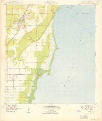
1949 Map of Perrine
USGS Topo · Published 1949About this map
Perrine and Peters anchor the coastal ridge of southern Florida in the years following World War II, a landscape defined by the Florida East Coast railroad and a burgeoning network of agricultural roads. The map reveals a transition from the established City of Coral Gables in the north toward the open wetlands and canal systems of the south. Water management is a primary feature of the terrain, with the Coconut Goulds Canal and Black Creek cutting through the limestone and sand toward Biscayne Bay. Coastal landmarks like Chicken Key and Black Pt remain largely undeveloped, while inland, family-named routes such as Moody Drive and Waldin Drive trace the early subdivision of the land into groves and farms. Smaller settlements like Franjo and South Allapattah show the era's rural settlement patterns before the rapid suburbanization of the late 20th century.
Find a feature on this map
20 named features on this map. Tap any name to fly to it.
Don’t see what you’re looking for? This feature index may not catch every label — zoom into the map to look around manually.
Map Details
Editions of this 1949 Perrine Map
2 editions found
Other maps of this area

1947 · Key Biscayne
USGS Topo · 1:24,000

1948 · Soldier Key
USGS Topo · 1:24,000

1949 · South Miami NW
USGS Topo · 1:24,000

1949 · Elliott Key
USGS Topo · 1:24,000

1949 · Key Biscayne
USGS Topo · 1:24,000

1949 · Arsenicker Keys
USGS Topo · 1:24,000

1949 · Goulds
USGS Topo · 1:24,000

1949 · Perrine
USGS Topo · 1:24,000

1950 · Homestead
USGS Topo · 1:24,000

1950 · South Miami
USGS Topo · 1:24,000