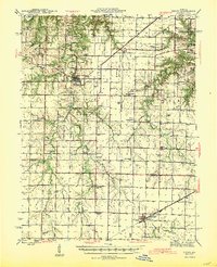
1945 Map of Perry
USGS Topo · Published 1945About this map
Perry and Farber serve as the primary hubs in this mid-century portrait of northeastern Missouri, situated where the borders of Ralls, Monroe, and Audrain counties converge. The landscape is defined by the winding course of the Salt River and its numerous tributaries, including Spencer Creek, Lick Creek, and Elk Creek. A significant shift in regional transportation is visible in the corridor of the St Louis and Hannibal (Abandoned) rail line, which contrasts with the active Alton Railroad passing through Farber to the south.
Find a feature on this map
58 named features on this map. Tap any name to fly to it.
Don’t see what you’re looking for? This feature index may not catch every label — zoom into the map to look around manually.
Map Details
Editions of this 1945 Perry Map
3 editions found

Other maps of this area

1890 · Louisiana
USGS Topo · 1:125,000

1890 · Mexico
USGS Topo · 1:125,000

1903 · Palmyra
USGS Topo · 1:125,000

1932 · Mexico
USGS Topo · 1:62,500

1932 · Hannibal
USGS Topo · 1:62,500

1936 · Hannibal
USGS Topo · 1:48,000

1942 · Wellsville
USGS Topo · 1:62,500

1942 · Bellflower
USGS Topo · 1:62,500

1943 · Vandalia
USGS Topo · 1:62,500

1945 · Florida
USGS Topo · 1:62,500