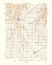
1945 Map of Perry
USGS Topo · Published 1945About this map
The Salt River meanders across the northern portion of this Ralls County landscape, creating a complex drainage network of creeks and branches including Pigeon Creek and Spencer Creek. In the mid-1940s, the town of Perry serves as a central hub, situated near the junction of the Hannibal and St Louis Highway and several local routes. Further south, the Alton railroad line cuts through the prairie, supporting the community of Farber and the nearby Alton Lake. The map reveals a dense rural infrastructure of one-room schoolhouses like Oakdale Sch and Wommach Sch, alongside family-named landmarks such as Bassingers Corner and Heavenridge. This pattern of settlement reflects an era when small agrarian communities and their local institutions still anchored the countryside before the consolidation of the mid-20th century.
Find a feature on this map
67 named features on this map. Tap any name to fly to it.
Don’t see what you’re looking for? This feature index may not catch every label — zoom into the map to look around manually.
Map Details
Editions of this 1945 Perry Map
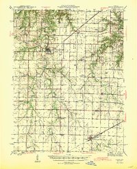
3 editions found

Other maps of this area

1890 · Louisiana
USGS Topo · 1:125,000

1890 · Mexico
USGS Topo · 1:125,000

1903 · Palmyra
USGS Topo · 1:125,000

1932 · Mexico
USGS Topo · 1:62,500

1932 · Hannibal
USGS Topo · 1:62,500

1936 · Hannibal
USGS Topo · 1:48,000

1942 · Wellsville
USGS Topo · 1:62,500

1942 · Bellflower
USGS Topo · 1:62,500

1943 · Vandalia
USGS Topo · 1:62,500

1945 · Florida
USGS Topo · 1:62,500