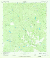
1969 Map of Pertle Creek
USGS Topo · Published 1972About this map
Hughey Lake and the branching drainage systems of McMullen County define this landscape as it appeared in the late 1960s. The map reveals a land utilized for ranching and resource extraction, characterized by numerous small tanks and isolated landmarks like a Landing Strip and a Flowing Well. The drainage patterns are intricate, with Pertle Creek joined by its North Prong and West Prong, while other named watercourses like Bill Walker Creek and Live Oak Creek carve through the brush country terrain. These features, along with a Drill Hole and several fence lines, illustrate the infrastructure of rural South Texas during an era of continued land development. Local historians and genealogists can trace property boundaries and water rights through features like Prairie Creek Tank and Maguey Creek, reflecting the essential relationship between water and survival in this arid region.
Find a feature on this map
15 named features on this map. Tap any name to fly to it.
Don’t see what you’re looking for? This feature index may not catch every label — zoom into the map to look around manually.
Map Details
Editions of this 1969 Pertle Creek Map
This is the sole edition of this map. No revisions or reprints were ever made.
Other maps of this area

1925 · Tilden No. 1
USGS Topo · 1:48,000

1930 · Tilden
USGS Topo · 1:62,500

1942 · Fowlerton
USGS Topo · 1:62,500

1942 · Tilden
USGS Topo · 1:62,500

1953 · Crystal City
USGS Topo · 1:250,000

1955 · Crystal City
USGS Topo · 1:250,000

1956 · Hindes
USGS Topo · 1:62,500

1956 · Franklin Settlement
USGS Topo · 1:62,500

1956 · Fowlerton
USGS Topo · 1:62,500

1961 · Crystal City
USGS Topo · 1:250,000