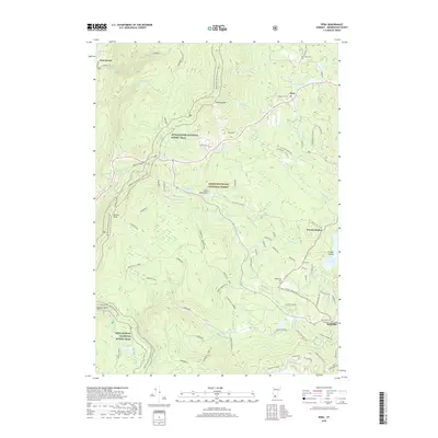
2018 Map of Peru
USGS Topo · Published 2018About this map
Green Mountain National Forest dominates the high ground of Bennington County, where the Appalachian National Scenic Trail winds through a landscape of significant peaks and watersheds. The terrain is defined by the steep slopes of Bromley Mtn and Spruce Peak, which separate the valley of East Dorset on the western edge from the mountain villages of Peru and Bondville to the east. This network of trails and forest roads, including Corridor 7 and the Catamount - Golden Spike trail, illustrates the region's 21st-century role as a center for outdoor recreation and conservation.
Find a feature on this map
77 named features on this map. Tap any name to fly to it.
Don’t see what you’re looking for? This feature index may not catch every label — zoom into the map to look around manually.
Map Details
Editions of this 2018 Peru Map
This is the sole edition of this map. No revisions or reprints were ever made.
Other maps of this area

1893 · Wallingford
USGS Topo · 1:62,500

1894 · Londonderry
USGS Topo · 1:62,500

1894 · Pawlet
USGS Topo · 1:62,500

1894 · Equinox
USGS Topo · 1:62,500

1896 · Equinox
USGS Topo · 1:62,500

1897 · Pawlet
USGS Topo · 1:62,500

1899 · Londonderry
USGS Topo · 1:62,500

1900 · Equinox
USGS Topo · 1:62,500

1903 · Mettawee
USGS Topo · 1:125,000

1950 · Glens Falls
USGS Topo · 1:250,000