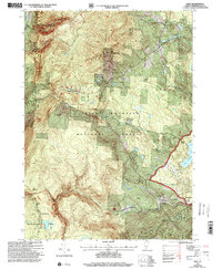
1997 Map of Peru
USGS Topo · Published 2000About this map
Bromley Mountain dominates the landscape of this portion of the Green Mountain National Forest, where the intersection of outdoor recreation and traditional Vermont settlement is clearly visible. The ridge line is home to the Big Bromley Winter Sports Area and Snow Valley Ski Area, while the Appalachian Trail winds through the high ground past the Spruce Peak Shelter and Douglas Shelter. In the valleys, the established villages of Peru and Bondville are connected by French Hollow Road, highlighting a transportation network dictated by the narrow gaps between peaks like Mad Tom Notch.
Find a feature on this map
35 named features on this map. Tap any name to fly to it.
Don’t see what you’re looking for? This feature index may not catch every label — zoom into the map to look around manually.
Map Details
Editions of this 1997 Peru Map
This is the sole edition of this map. No revisions or reprints were ever made.
Other maps of this area

1893 · Wallingford
USGS Topo · 1:62,500

1894 · Londonderry
USGS Topo · 1:62,500

1894 · Pawlet
USGS Topo · 1:62,500

1894 · Equinox
USGS Topo · 1:62,500

1896 · Equinox
USGS Topo · 1:62,500

1897 · Pawlet
USGS Topo · 1:62,500

1899 · Londonderry
USGS Topo · 1:62,500

1900 · Equinox
USGS Topo · 1:62,500

1903 · Mettawee
USGS Topo · 1:125,000

1950 · Glens Falls
USGS Topo · 1:250,000