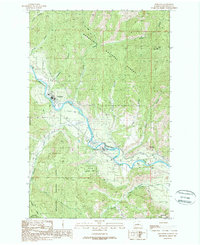
1989 Map of Peshastin
USGS Topo · Published 1989About this map
The Wenatchee River valley serves as the central artery for this late-twentieth-century landscape, where the communities of Peshastin and Dryden are defined by their proximity to vital water and transport infrastructure. The presence of the High Line Canal, Icicle Canal, and Wenatchee Canal illustrates a sophisticated irrigation network supporting the valley's agricultural development. Settlement patterns follow the river and the Burlington Northern railroad corridor, while the surrounding Wenatchee National Forest and numerous steep drainages like Derby Canyon and Williams Canyon constrain the habitable areas.
Find a feature on this map
30 named features on this map. Tap any name to fly to it.
Don’t see what you’re looking for? This feature index may not catch every label — zoom into the map to look around manually.
Map Details
Editions of this 1989 Peshastin Map
This is the sole edition of this map. No revisions or reprints were ever made.
Other maps of this area

1897 · Mount Stuart
USGS Topo · 1:125,000

1901 · Chelan
USGS Topo · 1:125,000

1901 · Chiwaukum
USGS Topo · 1:125,000

1902 · Mount Stuart
USGS Topo · 1:125,000

1904 · Chiwaukum
USGS Topo · 1:125,000

1913 · Wenatchee
USGS Topo · 1:62,500

1915 · Wenatchee
USGS Topo · 1:62,500

1920 · Colockum Pass
USGS Topo · 1:125,000

1922 · Colockum Pass
USGS Topo · 1:125,000

1957 · Wenatchee
USGS Topo · 1:250,000