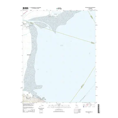
2015 Map of Petaluma Point
USGS Topo · Published 2015About this map
San Pablo Bay and the northern reaches of Novato dominate this coastal survey where the Petaluma River and Novato Creek meet the tidal marshes. The topography reveals a landscape shaped by water and elevation, from the wetlands surrounding Tubbs Island and Midshipman Point to the high ground of Chicken Coop Hill and Bullet Hill. The map traces the historical maritime routes of the area, including the Vallejo-San Francisco Fry and the Vallejo-Pier 41 Fry, which navigate the open waters of the Pacific Ocean entry into the bay. Along the southern shoreline, China Camp Point and Rat Rock mark the edge of the Back Ranch Meadows and Miwok Meadows, areas that preserve the names of the region's indigenous and ranching history. This record illustrates the intersection of growing residential areas like Black Point with the preserved open spaces of the bay's edge.
Find a feature on this map
36 named features on this map. Tap any name to fly to it.
Don’t see what you’re looking for? This feature index may not catch every label — zoom into the map to look around manually.
Map Details
Editions of this 2015 Petaluma Point Map
This is the sole edition of this map. No revisions or reprints were ever made.
Other maps of this area

1895 · San Francisco
USGS Topo · 1:62,500

1897 · Tamalpais
USGS Topo · 1:62,500

1899 · San Francisco
USGS Topo · 1:62,500

1902 · Napa
USGS Topo · 1:125,000

1914 · Petaluma
USGS Topo · 1:62,500

1915 · San Francisco
USGS Topo · 1:62,500

1916 · Mare Island
USGS Topo · 1:62,500

1941 · Tamalpais
USGS Topo · 1:62,500

1942 · Mare Island
USGS Topo · 1:62,500

1942 · Petaluma
USGS Topo · 1:62,500