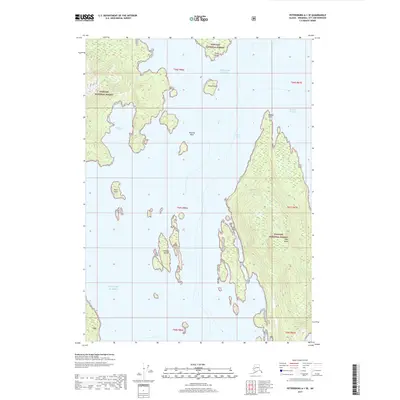
2017 Map of Petersburg A-1 SE
USGS Topo · Published 2017About this map
Deer Island dominates the eastern half of this coastal survey, situated within the expansive wilderness of the Tongass National Forest. The map documents the intricate coastline of Southeast Alaska, where the Seward Passage and Ernest Sound meet the open waters of the Gulf of Alaska. Navigational landmarks are scattered throughout these waters, from the isolated Blanche Rock to the clustered Niblack Islands. On the mainland and larger islands, the terrain is defined by prominent coastal features such as Kuakan Point and Thoms Point, alongside sheltered inlets like Southwest Cove. The layout of the islands, including Bold Island and Found Island, illustrates the complex maritime geography of the Alexander Archipelago. This 2017 edition provides a contemporary topographical perspective on the natural harborages and shoreline configurations used by modern mariners and researchers.
Find a feature on this map
18 named features on this map. Tap any name to fly to it.
Don’t see what you’re looking for? This feature index may not catch every label — zoom into the map to look around manually.
Map Details
Editions of this 2017 Petersburg A-1 SE Map
This is the sole edition of this map. No revisions or reprints were ever made.
Other maps of this area

1948 · Petersburg A-1
USGS Topo · 1:63,360

1949 · Craig D-1
USGS Topo · 1:63,360

1951 · Bradfield Canal
USGS Topo · 1:250,000

1951 · Craig D-1
USGS Topo · 1:63,360

1951 · Petersburg A-1
USGS Topo · 1:63,360

1952 · Petersburg
USGS Topo · 1:250,000

1952 · Ketchikan
USGS Topo · 1:250,000

1952 · Ketchikan D-6
USGS Topo · 1:63,360

1953 · Ketchikan D-6
USGS Topo · 1:63,360

1954 · Bradfield Canal
USGS Topo · 1:250,000