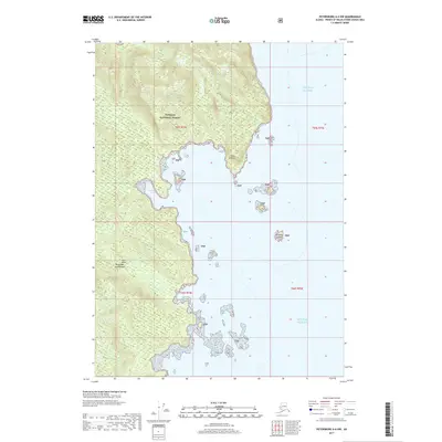
2017 Map of Petersburg A-6 NW
USGS Topo · Published 2017About this map
Kulu Island and its complex, indented shoreline define this coastal reach of the Alexander Archipelago. Most of the landmass is protected as part of the Tongass National Forest, showing a landscape of extreme topographic relief that rises sharply from the Gulf of Alaska. Navigational landmarks like Point Amelius and the sheltered waters of Louis Cove provide the only breaks in the rocky coastline. The maritime character of the region is further emphasized by Amelius Island and several smaller unnamed landmasses scattered off the coast. This map illustrates the intersection of a massive temperate rainforest and the open sea, where steep elevation contours nearly meet the tide line, creating a challenging environment for any settlement or development beyond the water's edge.
Find a feature on this map
12 named features on this map. Tap any name to fly to it.
Don’t see what you’re looking for? This feature index may not catch every label — zoom into the map to look around manually.
Map Details
Editions of this 2017 Petersburg A-6 NW Map
This is the sole edition of this map. No revisions or reprints were ever made.
Other maps of this area

1948 · Petersburg A-6
USGS Topo · 1:63,360

1948 · Port Alexander A-1
USGS Topo · 1:63,360

1948 · Petersburg B-6
USGS Topo · 1:63,360

1948 · Port Alexander B-1
USGS Topo · 1:63,360

1951 · Port Alexander
USGS Topo · 1:250,000

1951 · Petersburg B-6
USGS Topo · 1:63,360

1951 · Petersburg A-6
USGS Topo · 1:63,360

1952 · Petersburg
USGS Topo · 1:250,000

1952 · Port Alexander
USGS Topo · 1:250,000
1953 · Port Alexander B-1
USGS Topo · 1:63,360