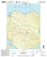
1995 Map of Petersburg B-3
USGS Topo · Published 1999About this map
Zarembo Island dominates this mid-1990s revision of the Alexander Archipelago, showing a landscape defined by the coastal management of the Tongass National Forest. The map documents a period of active maritime and forestry infrastructure, from the industrial presence of the Log Transfer Facility in the southwest to the strategic Lighthouse Reserve sites monitoring the surrounding waterways. Navigational transit is central to the area's geography, with the Alaska Marine Highway threading through Sumner Strait to the north. Surveyors noted specific technical landmarks such as a Weather Station and a USGS Communication Tower, alongside natural features like Meter Bight and Baht Harbor. The presence of several Fish Passes indicates the ongoing environmental management of the island's interior streams during this era.
Find a feature on this map
30 named features on this map. Tap any name to fly to it.
Don’t see what you’re looking for? This feature index may not catch every label — zoom into the map to look around manually.
Map Details
Editions of this 1995 Petersburg B-3 Map
This is the sole edition of this map. No revisions or reprints were ever made.
Other maps of this area

1948 · Petersburg A-2
USGS Topo · 1:63,360

1948 · Petersburg C-4
USGS Topo · 1:63,360

1948 · Petersburg C-2
USGS Topo · 1:63,360

1948 · Petersburg B-2
USGS Topo · 1:63,360

1948 · Petersburg C-3
USGS Topo · 1:63,360

1948 · Petersburg B-3
USGS Topo · 1:63,360

1949 · Petersburg A-3
USGS Topo · 1:63,360

1949 · Petersburg A-4
USGS Topo · 1:63,360

1949 · Petersburg B-4
USGS Topo · 1:63,360

1951 · Petersburg B-4
USGS Topo · 1:63,360