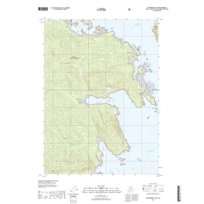
2017 Map of Petersburg B-6 NW
USGS Topo · Published 2017About this map
Tongass National Forest dominates this coastal landscape on Kuiu Island, where the complex shoreline of Southeast Alaska meets the open water. This 2017 survey shows a region defined by its deep maritime indentations, most notably Alvin Bay and Reid Bay, which carve into the island's timbered interior. The map illustrates a wilderness largely devoid of human settlements, focusing instead on the dramatic elevation changes and the numerous small islets and rocks designated as TNF land that pepper the coast. To the north and east, the map transitions into the Gulf of Alaska and the Pacific Ocean, with Conclusion Island standing as a sentinel at the northeastern edge of the sheet. The cartography provides a detailed look at the island's drainage patterns and forested ridges before the sea takes over.
Find a feature on this map
12 named features on this map. Tap any name to fly to it.
Don’t see what you’re looking for? This feature index may not catch every label — zoom into the map to look around manually.
Map Details
Editions of this 2017 Petersburg B-6 NW Map
This is the sole edition of this map. No revisions or reprints were ever made.
Other maps of this area

1948 · Port Alexander C-1
USGS Topo · 1:63,360

1948 · Petersburg B-6
USGS Topo · 1:63,360

1948 · Port Alexander B-1
USGS Topo · 1:63,360

1948 · Petersburg C-6
USGS Topo · 1:63,360

1951 · Port Alexander
USGS Topo · 1:250,000

1951 · Port Alexander C-1
USGS Topo · 1:63,360

1951 · Petersburg B-6
USGS Topo · 1:63,360

1952 · Petersburg
USGS Topo · 1:250,000

1952 · Port Alexander
USGS Topo · 1:250,000
1953 · Port Alexander B-1
USGS Topo · 1:63,360