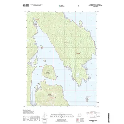
2017 Map of Petersburg B-6 SW
USGS Topo · Published 2017About this map
Port Beauclerc defines the western coastline of this island landscape, where deep inlets and sheltered bays meet the Pacific Ocean. This 2017 survey shows a region almost entirely contained within the Tongass National Forest, characterized by steep coastal terrain rising toward Beauclerc Peak. The map provides a contemporary look at the maritime geography of the Alexander Archipelago, tracing the intricate shoreline from Reid Bay in the north down to the southern reaches bordering the Gulf of Alaska. Navigational landmarks like Boulder Point and offshore features such as Edwards Island and Beauclerc Island reflect the area's significance for maritime transit and wilderness management. The lack of road infrastructure underscores the isolation and reliance on water-based travel in this part of Alaska's Panhandle.
Find a feature on this map
16 named features on this map. Tap any name to fly to it.
Don’t see what you’re looking for? This feature index may not catch every label — zoom into the map to look around manually.
Map Details
Editions of this 2017 Petersburg B-6 SW Map
This is the sole edition of this map. No revisions or reprints were ever made.
Other maps of this area

1948 · Petersburg A-6
USGS Topo · 1:63,360

1948 · Port Alexander A-1
USGS Topo · 1:63,360

1948 · Petersburg B-6
USGS Topo · 1:63,360

1948 · Port Alexander B-1
USGS Topo · 1:63,360

1951 · Port Alexander
USGS Topo · 1:250,000

1951 · Petersburg B-6
USGS Topo · 1:63,360

1951 · Petersburg A-6
USGS Topo · 1:63,360

1952 · Petersburg
USGS Topo · 1:250,000

1952 · Port Alexander
USGS Topo · 1:250,000
1953 · Port Alexander B-1
USGS Topo · 1:63,360