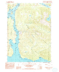
1992 Map of Petersburg C-3 SW
USGS Topo · Published 1992About this map
Mitkof Island serves as the central anchor of this Southeast Alaska coastal study, dominated by the heavily timbered reaches of the Tongass National Forest. The geography is defined by the vital maritime passage of the Wrangell Narrows, where intricate reefs and points such as Point Lockwood and December Point dictate the navigation of the Inside Passage. Along the western edge, the map details the fragmented shorelines of Kupreanof Island and the Lindenberg Peninsula, separated by the Keene Channel.
Find a feature on this map
32 named features on this map. Tap any name to fly to it.
Don’t see what you’re looking for? This feature index may not catch every label — zoom into the map to look around manually.
Map Details
Editions of this 1992 Petersburg C-3 SW Map
This is the sole edition of this map. No revisions or reprints were ever made.
Other maps of this area

1948 · Petersburg C-4
USGS Topo · 1:63,360

1948 · Petersburg C-3
USGS Topo · 1:63,360

1948 · Petersburg B-3
USGS Topo · 1:63,360

1949 · Petersburg B-4
USGS Topo · 1:63,360

1951 · Petersburg B-4
USGS Topo · 1:63,360

1951 · Petersburg B-3
USGS Topo · 1:63,360

1951 · Petersburg C-4
USGS Topo · 1:63,360

1952 · Petersburg
USGS Topo · 1:250,000

1953 · Petersburg C-3
USGS Topo · 1:63,360

1960 · Petersburg
USGS Topo · 1:250,000