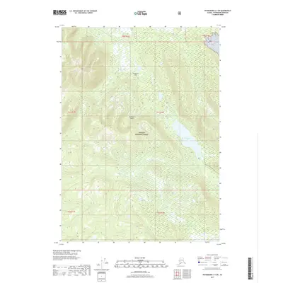
2017 Map of Petersburg C-4 SW
USGS Topo · Published 2017About this map
Kupreanof Island dominates this portion of the Alexander Archipelago, showing a landscape defined by the dense wilderness of the Tongass National Forest. The map detail centers on the hydrological connection between Kah Sheets Lake and the coast via Kah Sheets Cr, a critical drainage system for the interior basin. Human activity is represented primarily by the Kah Sheets Lake Trail, which skirts the eastern shore of the lake. The terrain is marked by steep elevation changes and intricate water systems, including the headwaters of Middle Cr. This 2017 survey reflects the enduring character of the Alaska panhandle, where land use is dictated by the constraints of the national forest and the natural paths carved by glacial and fluvial processes.
Find a feature on this map
12 named features on this map. Tap any name to fly to it.
Don’t see what you’re looking for? This feature index may not catch every label — zoom into the map to look around manually.
Map Details
Editions of this 2017 Petersburg C-4 SW Map
This is the sole edition of this map. No revisions or reprints were ever made.
Other maps of this area

1948 · Petersburg C-4
USGS Topo · 1:63,360

1948 · Petersburg C-5
USGS Topo · 1:63,360

1949 · Petersburg B-5
USGS Topo · 1:63,360

1949 · Petersburg B-4
USGS Topo · 1:63,360

1951 · Petersburg B-4
USGS Topo · 1:63,360

1951 · Petersburg C-4
USGS Topo · 1:63,360

1951 · Petersburg C-5
USGS Topo · 1:63,360

1952 · Petersburg
USGS Topo · 1:250,000
1953 · Petersburg B-5
USGS Topo · 1:63,360

1960 · Petersburg
USGS Topo · 1:250,000