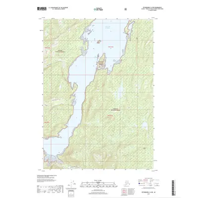
2017 Map of Petersburg C-6 NW
USGS Topo · Published 2017About this map
Kuiu Island dominates this coastal survey, where the dense timber of the Tongass National Forest meets the intricate inlets of the Alexander Archipelago. The landscape is defined by the deep indentation of Port Camden, a waterway that nearly bisects the island. For those tracing the history of industrial access in the region, the presence of the Kuiu Mainline logging road and the Threemile Arm Portage Trail illustrates the essential transport corridors used for timber extraction and wilderness navigation. Freshwater features like E Fork Kadake Creek and Beaver Pond dot the interior, while Cam Island sits at the mouth of the bay where it opens into the Gulf of Alaska. This 2017 study provides a precise view of the topography and modern forest service infrastructure across this remote portion of the Petersburg Borough.
Find a feature on this map
17 named features on this map. Tap any name to fly to it.
Don’t see what you’re looking for? This feature index may not catch every label — zoom into the map to look around manually.
Map Details
Editions of this 2017 Petersburg C-6 NW Map
This is the sole edition of this map. No revisions or reprints were ever made.
Other maps of this area

1948 · Port Alexander C-1
USGS Topo · 1:63,360

1948 · Petersburg D-6
USGS Topo · 1:63,360

1948 · Port Alexander D-1
USGS Topo · 1:63,360

1948 · Petersburg C-6
USGS Topo · 1:63,360

1951 · Port Alexander
USGS Topo · 1:250,000

1951 · Petersburg D-6
USGS Topo · 1:63,360

1951 · Port Alexander C-1
USGS Topo · 1:63,360

1952 · Petersburg
USGS Topo · 1:250,000

1952 · Port Alexander
USGS Topo · 1:250,000

1960 · Petersburg
USGS Topo · 1:250,000