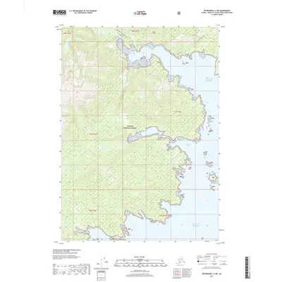
2017 Map of Petersburg C-6 SW
USGS Topo · Published 2017About this map
Kuiu Island, an expansive landmass within the Tongass National Forest, dominates this coastal survey of Southeast Alaska. The landscape is defined by the intricate shoreline of Seclusion Harbor and the northern reach of the Gulf of Alaska. Navigational routes across the island's timbered interior include the Kuiu Mainline and the historic Threemile Arm Portage Trail, which provides a vital overland link between coastal inlets. The map illustrates a remote wilderness managed for natural resources, where the topography transitions from sea-level coves to the high ridgelines of the Alexander Archipelago. Sparse infrastructure is limited to these established forest trails and logging roads, reflecting the region's focus on conservation and industrial forestry in the early 21st century.
Find a feature on this map
14 named features on this map. Tap any name to fly to it.
Don’t see what you’re looking for? This feature index may not catch every label — zoom into the map to look around manually.
Map Details
Editions of this 2017 Petersburg C-6 SW Map
This is the sole edition of this map. No revisions or reprints were ever made.
Other maps of this area

1948 · Port Alexander C-1
USGS Topo · 1:63,360

1948 · Petersburg B-6
USGS Topo · 1:63,360

1948 · Port Alexander B-1
USGS Topo · 1:63,360

1948 · Petersburg C-6
USGS Topo · 1:63,360

1951 · Port Alexander
USGS Topo · 1:250,000

1951 · Port Alexander C-1
USGS Topo · 1:63,360

1951 · Petersburg B-6
USGS Topo · 1:63,360

1952 · Petersburg
USGS Topo · 1:250,000

1952 · Port Alexander
USGS Topo · 1:250,000
1953 · Port Alexander B-1
USGS Topo · 1:63,360