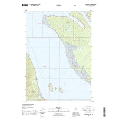
2017 Map of Petersburg D-3 NW
USGS Topo · Published 2017About this map
Tongass National Forest dominates this coastal Alaska landscape, where the tides of Frederick Sound meet a shoreline of points and inlets. The map highlights the rugged maritime geography of the Point Agassiz Peninsula, stretching between Thomas Bay to the north and the open sound to the south. Land-based navigation is represented by the Colp Lake Trail and the Point Agassiz Connection, providing rare inland access through the dense forest. Notable coastal landmarks such as Beacon Point and Wood Point flank the peninsula, while the isolated Sukoi Islets sit offshore within the sound. This 2017 survey reflects the remote, wilderness-focused character of the region, where activity is concentrated along the waterline and a few established forest routes like Fivemile Cr.
Find a feature on this map
19 named features on this map. Tap any name to fly to it.
Don’t see what you’re looking for? This feature index may not catch every label — zoom into the map to look around manually.
Map Details
Editions of this 2017 Petersburg D-3 NW Map
This is the sole edition of this map. No revisions or reprints were ever made.
Other maps of this area

1948 · Sumdum A-4
USGS Topo · 1:63,360

1951 · Petersburg D-4
USGS Topo · 1:63,360

1951 · Sumdum A-4
USGS Topo · 1:63,360

1952 · Petersburg
USGS Topo · 1:250,000

1952 · Sumdum
USGS Topo · 1:250,000

1960 · Petersburg
USGS Topo · 1:250,000

1961 · Petersburg D-3
USGS Topo · 1:63,360

1961 · Sumdum A-3
USGS Topo · 1:63,360

1961 · Sumdum
USGS Topo · 1:250,000
1992 · Petersburg D-4 SE
USGS Topo · 1:25,000