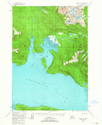
1951 Map of Sumdum A-4
USGS Topo · Published 1964About this map
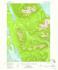
Farragut Bay and the northern reaches of Kupreanof Island dominate this coastal survey, where the glacial landscape meets the deep waters of Frederick Sound. Settlement is sparse, limited to a few isolated Cabins and a lone Cabin situated near the intersection of the North Arm and South Arm. This environment was documented just before the mid-century, capturing the area before modern navigation and infrastructure altered the access to these remote waterways.
Find a feature on this map
34 named features on this map. Tap any name to fly to it.
Don’t see what you’re looking for? This feature index may not catch every label — zoom into the map to look around manually.
Map Details
Editions of this 1951 Sumdum A-4 Map
2 editions found

Other maps of this area

1943 · Sumdum B-4
USGS Topo · 1:63,360

1948 · Sumdum A-4
USGS Topo · 1:63,360
1948 · Sumdum A-5
USGS Topo · 1:63,360

1948 · Sumdum B-5
USGS Topo · 1:63,360
1948 · Sumdum B-4
USGS Topo · 1:63,360
1948 · Petersburg D-5
USGS Topo · 1:63,360
1951 · Petersburg D-4
USGS Topo · 1:63,360

1951 · Sumdum B-5
USGS Topo · 1:63,360

1952 · Petersburg
USGS Topo · 1:250,000
1952 · Sumdum
USGS Topo · 1:250,000