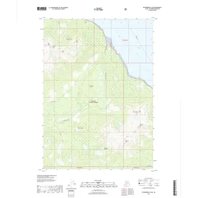
2017 Map of Petersburg D-4 NE
USGS Topo · Published 2017About this map
Kupreanof Island dominates this 2017 survey, showcasing a mountainous landscape within the Tongass National Forest along the eastern shore of Frederick Sound. The terrain is defined by a series of prominent summits, including Missionary Mountain, Sheridan Peak, and Sherman Peak, which overlook the complex drainage systems of Twelvemile Cr and Fivemile Cr. Along the northern coastline, Cape Strait stands as a navigational landmark for the Ferry Route threading through the sound. Local nomenclature is captured in labels like Mad Woman and Goose Creek, while the Colp Lake Trail indicates managed access into the interior. This map documents the intersection of maritime transport and the high-elevation wilderness of the Alexander Archipelago.
Find a feature on this map
25 named features on this map. Tap any name to fly to it.
Don’t see what you’re looking for? This feature index may not catch every label — zoom into the map to look around manually.
Map Details
Editions of this 2017 Petersburg D-4 NE Map
This is the sole edition of this map. No revisions or reprints were ever made.
Other maps of this area

1948 · Sumdum A-4
USGS Topo · 1:63,360

1951 · Petersburg D-4
USGS Topo · 1:63,360

1951 · Sumdum A-4
USGS Topo · 1:63,360

1952 · Petersburg
USGS Topo · 1:250,000

1952 · Sumdum
USGS Topo · 1:250,000

1960 · Petersburg
USGS Topo · 1:250,000

1961 · Petersburg D-3
USGS Topo · 1:63,360

1961 · Sumdum A-3
USGS Topo · 1:63,360

1961 · Sumdum
USGS Topo · 1:250,000
1992 · Petersburg D-4 SE
USGS Topo · 1:25,000