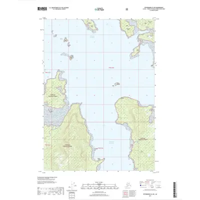
2017 Map of Petersburg D-6 SW
USGS Topo · Published 2017About this map
Keku Strait and the northern reaches of Port Camden dominate this coastal survey of the Alexander Archipelago. This portion of the Tongass National Forest is characterized by a complex network of islands and tidal inlets, including the southern shores of Kupreanof Island. The map records distinct maritime landmarks such as Point Camden and Salt Point, which frame the entrance to Dakaneek Bay. These waters, part of the Gulf of Alaska, are dotted with smaller landforms like Hound Island, Hare Island, and Clark Island. The topography consists of heavily forested, steep-sided ridges that rise sharply from the shoreline, particularly around the protected waters of Gil Harbor. This 2017 edition provides a precise look at the wilderness coastline and forest boundaries before more recent changes to federal land management in the region.
Find a feature on this map
19 named features on this map. Tap any name to fly to it.
Don’t see what you’re looking for? This feature index may not catch every label — zoom into the map to look around manually.
Map Details
Editions of this 2017 Petersburg D-6 SW Map
This is the sole edition of this map. No revisions or reprints were ever made.
Other maps of this area

1948 · Port Alexander C-1
USGS Topo · 1:63,360

1948 · Petersburg D-6
USGS Topo · 1:63,360

1948 · Port Alexander D-1
USGS Topo · 1:63,360

1948 · Petersburg C-6
USGS Topo · 1:63,360

1951 · Port Alexander
USGS Topo · 1:250,000

1951 · Petersburg D-6
USGS Topo · 1:63,360

1951 · Port Alexander C-1
USGS Topo · 1:63,360

1952 · Petersburg
USGS Topo · 1:250,000

1952 · Port Alexander
USGS Topo · 1:250,000

1960 · Petersburg
USGS Topo · 1:250,000