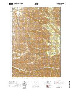
2020 Map of Peterson Ridge
USGS Topo · Published 2020About this map
Peterson Ridge and Blalock Mtn anchor this high-elevation corner of Umatilla County, where the landscape is defined by the deep drainage systems of the N Fork Walla Walla River and the numerous branches of Cottonwood Cr. The map reveals a network of early access routes including the Morman Grade and Saddle Mountain Rd that navigate the ridges between Pikes Peak and Saddle Mtn. This area's geography is characterized by distinct landforms like Pumpkin Hollow and Cup Gulch, illustrating the complex erosion patterns north of the Walla Walla River. The distribution of roads such as Government Mountain Rd suggests a landscape managed for timber or grazing, with small clearings like Little Meadows providing breaks in the high-country terrain of Pine Ridge.
Find a feature on this map
31 named features on this map. Tap any name to fly to it.
Don’t see what you’re looking for? This feature index may not catch every label — zoom into the map to look around manually.
Map Details
Editions of this 2020 Peterson Ridge Map
This is the sole edition of this map. No revisions or reprints were ever made.
Other maps of this area

1919 · Walla Walla
USGS Topo · 1:125,000

1921 · Walla Walla
USGS Topo · 1:125,000

1953 · Pendleton
USGS Topo · 1:250,000

1953 · Walla Walla
USGS Topo · 1:250,000

1956 · Pendleton
USGS Topo · 1:250,000

1958 · Walla Walla
USGS Topo · 1:250,000

1963 · Big Meadows
USGS Topo · 1:24,000

1963 · Tollgate
USGS Topo · 1:24,000

1963 · Blalock Mountain
USGS Topo · 1:24,000

1963 · Peterson Ridge
USGS Topo · 1:24,000