
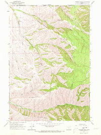
1963 Map of Peterson Ridge
USGS Topo · Published 1965About this map
The North Fork Walla Walla River and its various tributaries carve through the dramatic high country along the border of Oregon and Washington. This 1960s survey captures the intersection of Umatilla Co and Walla Walla Co within a landscape defined by prominent geographical landmarks like Saddle Mountain and Blalock Mountain. The terrain is marked by a complex system of ridges, including Pine Ridge and Peterson Ridge, which channel water into Middle Fork Walla Walla River and South Fork Walla Walla River. Communication and transport infrastructure of the mid-century are evidenced by the Pikes Peak Radio Tower and the winding path of Mormon Grade. Lower elevations near Little Meadows and the various springs throughout the canyons suggest the vital role of water management in this high-altitude drainage basin.
Find a feature on this map
21 named features on this map. Tap any name to fly to it.
Don’t see what you’re looking for? This feature index may not catch every label — zoom into the map to look around manually.
Map Details
Editions of this 1963 Peterson Ridge Map
2 editions found
Other maps of this area

1919 · Walla Walla
USGS Topo · 1:125,000

1921 · Walla Walla
USGS Topo · 1:125,000

1953 · Pendleton
USGS Topo · 1:250,000

1953 · Walla Walla
USGS Topo · 1:250,000

1956 · Pendleton
USGS Topo · 1:250,000

1958 · Walla Walla
USGS Topo · 1:250,000

1963 · Big Meadows
USGS Topo · 1:24,000

1963 · Tollgate
USGS Topo · 1:24,000

1963 · Blalock Mountain
USGS Topo · 1:24,000

1964 · Bowlus Hill
USGS Topo · 1:24,000