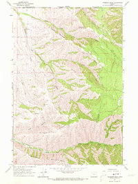
1963 Map of Peterson Ridge
USGS Topo · Published 1973About this map
Peterson Ridge and the high country of the Blue Mountains dominate this 1960s survey along the boundary between Washington and Oregon. This area, divided between Walla Walla and Umatilla Counties, is defined by its dramatic drainage systems, including the headwaters of the North Fork Walla Walla River and the deeply cut Little Meadow Canyon. The landscape is etched with steep ridges like Pine Ridge and Blalock Mountain, reflecting a remote terrain where transit was limited to early roads and a Jeep Trail.
Find a feature on this map
23 named features on this map. Tap any name to fly to it.
Don’t see what you’re looking for? This feature index may not catch every label — zoom into the map to look around manually.
Map Details
Editions of this 1963 Peterson Ridge Map
2 editions found
Other maps of this area

1919 · Walla Walla
USGS Topo · 1:125,000

1921 · Walla Walla
USGS Topo · 1:125,000

1953 · Pendleton
USGS Topo · 1:250,000

1953 · Walla Walla
USGS Topo · 1:250,000

1956 · Pendleton
USGS Topo · 1:250,000

1958 · Walla Walla
USGS Topo · 1:250,000

1963 · Big Meadows
USGS Topo · 1:24,000

1963 · Tollgate
USGS Topo · 1:24,000

1963 · Blalock Mountain
USGS Topo · 1:24,000

1963 · Peterson Ridge
USGS Topo · 1:24,000