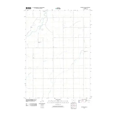
2010 Map of Peterson SW
USGS Topo · Published 2010About this map
The Little Sioux River and Maple River converge in this corner of Buena Vista County, defining a landscape shaped by glacial waterways and early twentieth-century agriculture. The small settlement of Maple sits near the center of the grid, surrounded by a network of rural roads such as Martin Access Rd and Barnes Rd. The distribution of burial grounds across the township—including Spring Cemetery, Spring Township Cemetery, Afton Cemetery, and Immanuel Lutheran Cemetery—points to the distinct clusters of family and church settlements that once anchored this prairie region. Modern recreational use is noted at the SooRiver Access, while the meandering paths of Badger Creek and the rivers contrast sharply with the rigid section lines of the surrounding farmland.
Find a feature on this map
27 named features on this map. Tap any name to fly to it.
Don’t see what you’re looking for? This feature index may not catch every label — zoom into the map to look around manually.
Map Details
Editions of this 2010 Peterson SW Map
This is the sole edition of this map. No revisions or reprints were ever made.
Other maps of this area

1954 · Fort Dodge
USGS Topo · 1:250,000

1957 · Fort Dodge
USGS Topo · 1:250,000

1958 · Fort Dodge
USGS Topo · 1:250,000

1969 · Aurelia
USGS Topo · 1:24,000

1969 · Cherokee South
USGS Topo · 1:24,000

1971 · Peterson SW
USGS Topo · 1:24,000

1971 · Peterson SE
USGS Topo · 1:24,000
1971 · Peterson
USGS Topo · 1:24,000
1971 · Sutherland West
USGS Topo · 1:24,000
1971 · Sutherland East
USGS Topo · 1:24,000