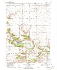
1971 Map of Peterson
USGS Topo · Published 1973About this map
Peterson sits as a primary settlement along the winding course of the Little Sioux River, just north of the Clay and Buena Vista county line. This early 1970s survey captures a landscape defined by the river’s deep meanders and the Chicago and North Western railroad that parallels its banks. The presence of Wanata State Park and Buena Vista County Park highlights a corridor of preserved land along the bluffs, contrasting with the expansive agricultural sections of Lincoln and Peterson townships. Genealogy and local history details include the Oakland Cem and Bartram Camp, while small industrial footprints are marked by scattered Gravel Pits and the municipal Sew Disp Pond serving the town.
Find a feature on this map
19 named features on this map. Tap any name to fly to it.
Don’t see what you’re looking for? This feature index may not catch every label — zoom into the map to look around manually.
Map Details
Editions of this 1971 Peterson Map
This is the sole edition of this map. No revisions or reprints were ever made.
Other maps of this area

1954 · Fairmont
USGS Topo · 1:250,000

1954 · Fort Dodge
USGS Topo · 1:250,000

1957 · Fort Dodge
USGS Topo · 1:250,000

1958 · Fort Dodge
USGS Topo · 1:250,000

1958 · Fairmont
USGS Topo · 1:250,000

1966 · Greenville
USGS Topo · 1:24,000

1970 · Hartley SW
USGS Topo · 1:24,000

1970 · Royal
USGS Topo · 1:24,000

1971 · Rembrandt
USGS Topo · 1:24,000

1971 · Sioux Rapids
USGS Topo · 1:24,000