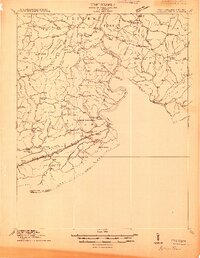
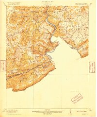
1925 Map of Peterstown
USGS Topo · Published 1925About this map
The New River carves a dramatic path through the borderlands of West Virginia and Virginia, punctuated by the striking water gap at The Narrows. This mid-1920s survey captures a landscape defined by steep ridges and localized industry, most notably at Mercers Saltworks and the heavy engineering of the Norfolk and Western Ry and Virginian Ry lines. The rail corridors hug the narrow banks of the East River, passing through the Hales Gap Tunnel to connect the settlements of Oakvale and Kellysville. Rural life in this period is evidenced by a dense network of mountain schools, including the vividly named Scratchgravel School, Mudhole School, and Chestnut Knob School. Transportation across the water relies on historic crossings like Shanklins Ferry and the rail hub at Wills Sta Willowton PO, serving a community scattered between Peterstown and the high slopes of Peters Mtn.
Find a feature on this map
107 named features on this map. Tap any name to fly to it.
Don’t see what you’re looking for? This feature index may not catch every label — zoom into the map to look around manually.
Map Details
Editions of this 1925 Peterstown Map
This is the sole edition of this map. No revisions or reprints were ever made.
Historical Maps of Pearisburg Through Time
5 maps found