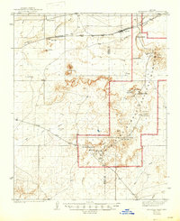
1912 Map of Petrified Forest
USGS Topo · Published 1947About this map
The Atchison Topeka and Santa Fe railroad corridor anchors the northern reach of this landscape, passing through the small settlement of Adamana and past Goodwater along the Puerco River. This 1912 edition, based on surveys by J.G. Staack, Pearson Chapman, and G.S. Druhot, captures the area during the early years of the Petrified Forest National Monument. The map documents a geography of erosion and discovery, identifying key paleontological and archaeological sites like Newspaper Rock, the Agate House, and various unnamed Ruins.
Find a feature on this map
38 named features on this map. Tap any name to fly to it.
Don’t see what you’re looking for? This feature index may not catch every label — zoom into the map to look around manually.
Map Details
Editions of this 1912 Petrified Forest Map
2 editions found
Other maps of this area

1883 · Tusayan
USGS Topo · 1:250,000

1886 · St Johns
USGS Topo · 1:250,000

1886 · Tusayan
USGS Topo · 1:250,000

1886 · Fort Defiance
USGS Topo · 1:250,000

1886 · Holbrook
USGS Topo · 1:250,000

1892 · Fort Defiance
USGS Topo · 1:250,000

1892 · St Johns
USGS Topo · 1:250,000

1893 · Holbrook
USGS Topo · 1:250,000
1912 · Petrified Forest
USGS Topo · 1:62,500

1947 · Flagstaff
USGS Topo · 1:250,000