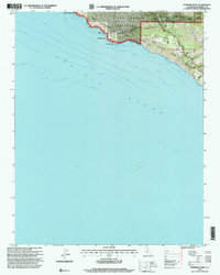
1995 Map of Pfeiffer Point
USGS Topo · Published 2000About this map
The Pacific Ocean coastline dominates this 1995 revision, where the dramatic interface of the Santa Lucia Range meets the sea. Centered on the designated California Sea Otter State Game Refuge, the landscape is a mosaic of protected lands including the Los Padres National Forest and Big Sur State Park. The map documents the localized human footprint in this environment, showing the clustered buildings at Posts, the Resort, and the Big Sur Multiagency Facility.
Find a feature on this map
24 named features on this map. Tap any name to fly to it.
Don’t see what you’re looking for? This feature index may not catch every label — zoom into the map to look around manually.
Map Details
Editions of this 1995 Pfeiffer Point Map
This is the sole edition of this map. No revisions or reprints were ever made.
Other maps of this area

1918 · Point Sur
USGS Topo · 1:62,500

1920 · Jamesburg
USGS Topo · 1:48,000

1921 · Jamesburg
USGS Topo · 1:62,500

1921 · Lucia
USGS Topo · 1:62,500

1925 · Point Sur
USGS Topo · 1:62,500

1939 · Jamesburg
USGS Topo · 1:62,500

1940 · Jamesburg
USGS Topo · 1:62,500

1941 · Lucia
USGS Topo · 1:62,500

1947 · Lucia
USGS Topo · 1:62,500

1947 · Jamesburg
USGS Topo · 1:62,500