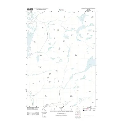
2013 Map of Pharaoh Mountain
USGS Topo · Published 2013About this map
Pharaoh Mountain rises as the central landmark of this Adirondack region, overlooking a complex network of glacial ponds and wetlands. The landscape is defined by its water, from the winding Schroon River and the northern tip of Schroon Lake to the secluded Pharaoh Lake and Pyramid Lake. This terrain is characterized by numerous small peaks and hills, many named for local families or simple numbers, such as Franks Hill, Smith and Leland Hill, and Number Eight Hill. To the northwest, the Schroon Lake Airport provides a modern point of access, while roads like Adirondack Rd and Crane Pond Rd offer entry into the wooded interior. The abundance of water bodies like Glidden Marsh, Whortleberry Pond, and Spectacle Pond highlights the region's natural drainage patterns centered around Mill Brook and Sucker Brook.
Find a feature on this map
75 named features on this map. Tap any name to fly to it.
Don’t see what you’re looking for? This feature index may not catch every label — zoom into the map to look around manually.
Map Details
Editions of this 2013 Pharaoh Mountain Map
This is the sole edition of this map. No revisions or reprints were ever made.
Other maps of this area

1895 · North Creek
USGS Topo · 1:62,500

1895 · Paradox Lake
USGS Topo · 1:62,500

1897 · Bolton
USGS Topo · 1:62,500

1897 · Paradox Lake
USGS Topo · 1:62,500

1897 · North Creek
USGS Topo · 1:62,500

1897 · Schroon Lake
USGS Topo · 1:62,500

1900 · Bolton
USGS Topo · 1:62,500

1950 · Glens Falls
USGS Topo · 1:250,000
1953 · Paradox Lake
USGS Topo · 1:62,500

1953 · Schroon Lake
USGS Topo · 1:62,500