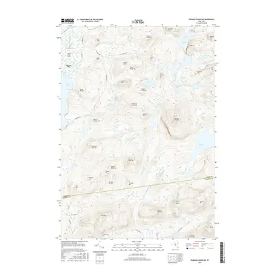
2016 Map of Pharaoh Mountain
USGS Topo · Published 2016About this map
Pharaoh Mountain anchors this Adirondack landscape, where the high peaks of the Pharaoh Lake Wilderness meet the eastern shores of Schroon Lake. The terrain is defined by a dense network of high-elevation water bodies and complex drainage patterns, including the massive Harrison Marsh and the isolated Desolate Swamp. To the northwest, the Schroon Lake Airport sits near the base of Owls Head, marking the transition from the settled lakeside corridor into the more interior highlands. The map reveals a numbered series of summits such as Number Six Hill and Number Seven Hill stretching toward the boundary between Essex Co and Warren Co. This survey documents the modern state of these protected lands, showing the many interior ponds like Crane Pond and Whortleberry Pond that remain accessible only by a limited network of remote roads like Crane Pond Rd.
Find a feature on this map
80 named features on this map. Tap any name to fly to it.
Don’t see what you’re looking for? This feature index may not catch every label — zoom into the map to look around manually.
Map Details
Editions of this 2016 Pharaoh Mountain Map
This is the sole edition of this map. No revisions or reprints were ever made.
Other maps of this area

1895 · North Creek
USGS Topo · 1:62,500

1895 · Paradox Lake
USGS Topo · 1:62,500

1897 · Bolton
USGS Topo · 1:62,500

1897 · Paradox Lake
USGS Topo · 1:62,500

1897 · North Creek
USGS Topo · 1:62,500

1897 · Schroon Lake
USGS Topo · 1:62,500

1900 · Bolton
USGS Topo · 1:62,500

1950 · Glens Falls
USGS Topo · 1:250,000
1953 · Paradox Lake
USGS Topo · 1:62,500

1953 · Schroon Lake
USGS Topo · 1:62,500